
City Proposes Changes to Comprehensive Plan for Section 35
On September 13, 2015, the Common Council voted to approve this proposal 7-0.
Status
| Oct 13, 2015 | Common Council Meeting Common Council voted to adopt ordinance #2553 to amend the Comprehensive Plan Meeting Minutes w/ video - PDF |
|---|---|
| Oct 5, 2015 | Plan Commission Meeting - Resolution Passed Unanimously Passed to the Common Council for approval at Oct 13, 2015 Meeting Meeting Minutes w/ video - PDF |
| Sep 9, 2015 | Plan Commission Public Hearing Held (Hearing - No Action) Meeting Minutes w/ video of the public hearing - PDF |
What's Happening?
From the city's web site:
The Department of Community Development has recently completed an extensive public participation effort regarding the future planning and Comprehensive Plan amendments for the South Moorland Road Corridor located within Sections 34 and 35. The purpose of the public outreach efforts was to gather input on proposed Future Land Use map changes within the South Moorland Road Neighborhood planning area.
The area affected by this proposal is bounded by Moorland Road, Grange Avenue, Sunny Slope Road, and College Avenue, and is referred to as Section 35.
As recently as 2008-2009, the city's 2020 Comprehensive Plan was developed and the Eastern portion of Section 35 was specifically designated for residential development. Area residents counted on that Comprehensive Plan when they decided to live in the surrounding areas, so changes should not be made to those plans without good reason and without the input/approval of the residents of the city, especially those most affected by the changes.
While it is not reasonable to expect full retention of agricultural uses in the long term, there is an opportunity to balance new development with the preservation of natural features.
The Proposed Changes
Using input from many interested parties (area residents, landowners, potential developers, etc.), the Department of Community Development has created a plan that would convert the (approximately) 412 acres of land that is currently reserved for residential development into the following uses:
- ~297 acres of residential development (including non-buildable land) that would have a similar density to High Grove and Karrington Woods (1 dwelling per 1/2 acre instead of 1 dwelling per 2 acres, which is the current usage specified in the Comprehensive Plan)
- ~95 acres of parkland that may be used as a sports complex (baseball fields, lights, fences, etc.)
- ~20 acres of additional land added to the Industrial Park
The city has a page on its web site called the "South Moorland Rd. Corridor-Neighborhood Plan" that details the proposed changes. Please review that information, as it is the official source of that information.
The city held a series of Open House meetings this past summer and sent out invitations to 12,000+ households (according to the city staff), presenting (an earlier version of) the currently proposed plan, and asking for public input.
Our Involvement
For more than a year, several residents from High Grove, Karrington Woods, and Woodfield Estates have been serving as liaisons of the people in those and other nearby subdivisions that expressed opposition to the 2012 proposal and/or will be impacted by these developments. We have met with the Mayor, Alderman Ken Harenda, Director of Community Development Greg Kessler, and other city staff to act as representatives for our neighbors in these "small group" discussions.
We have been communicating information and participating in discussions in a Google Groups mailing list. The discussions that happened on that mailing list and conversations that we've had with our neighbors have been the basis for much of the discussion during those meetings.
The city has listened very intently to our concerns, but they also have other interested parties involved as well, including landowners of the land in question and prospective developers looking to build commercial and residential projects in that area. We do not agree with every aspect of this current proposal, but some of what is being presented reflects our discussions and viewpoints. At this point, the time for such "small group" discussion is done, and it's up to the citizens of New Berlin to voice their opinions of what is being presented to them by the city.
Some History
Back in 2012, the city considered a proposal that would have changed the way land was used in Section 35 to expand significantly the amount of land used Industrial Park. Due to citizen opposition, and with cooperation with some of the aldermen, that plan was rescinded.
However, we knew that the land in question was too valuable to think that new proposals would never come to change the Comprehensive Plan from its intended usage. Read more about the 2012 opposition effort.
Last Updated: Oct 15, 2015
Related Files
Map of Area
Related Links
- South Moorland Rd. Corridor-Neighborhood Plan - City of New Berlin web site
- City of New Berlin Moorland Road Business Corridor South Development Facebook Page -- Facebook
- New Berlin Meeting Agendas, Minutes, and Videos - City of New Berlin web site
Documents
- Plan Overview (Map) -- City of New Berlin web site
- Plan Overview (Aerial Image) -- City of New Berlin web site

Capture of Google Earth showing overhead view of the area from the east
City Contact Information
If you have questions, concerns, or other feedback about this proposal, please take the time to contact city staff and our city leaders!
- Community Development Department
(262) 786-8610 — E-Mail - Plan Commission
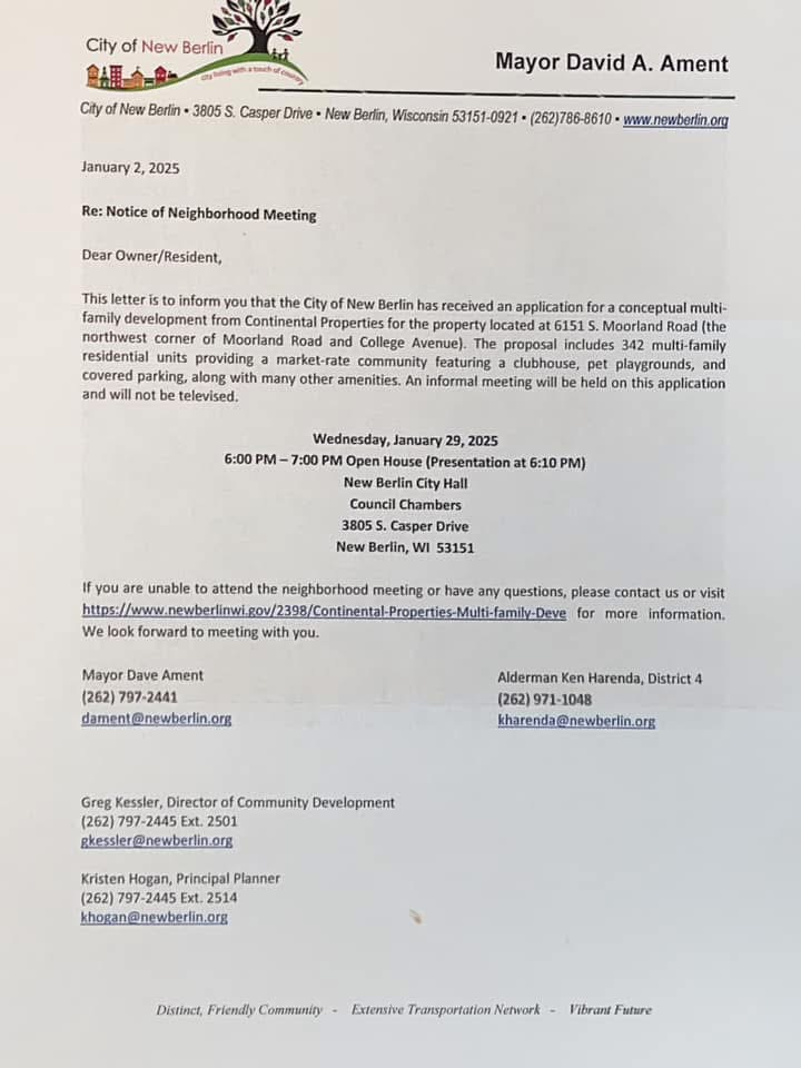
- Mayor Dave Ament
(262) 797-2441 — E-Mail - Alderman Ken Harenda - 4th District (which includes Section 35)
E-Mail
Related Pages
Check us out on Facebook!
Please note: This site does not represent the City of New Berlin, the School District of New Berlin, or any other organization that may be referenced here. It is produced by citizens of New Berlin for the citizens of New Berlin, and is not endorsed by any of the aforementioned organizations.